This is also one of the more isolated sections of The Colorado Trail. For the unsupported hiker, re-supply towns are few and far between. The support crew has to travel great distances at times to reach the day’s final destination. For the non-supported hiker, water availability becomes a problem after Bolam Pass. However, the supported hiking trek carries ample potable water so the clients do not have to be concerned. The meeting time for this section is at 12:00 p.m. giving hikers at their option an opportunity to hike a small section of The Colorado Trail in the afternoon. We also like to get to this campsite early allowing you to set up your personal sleeping tent before the thunderstorms come in!
Aug 3 - 8, 2026
A week-long guided trek on the Colorado Trail, Segments 25 - 28.
Column
$ 1950
Per Hiker- Dates: August 3 – 8, 2025
- Section 7: Indian Trail Ridge
- CT Segments: 25, 26, 27, 28
- Min/Max: 6/12


Molas Pass to Durango
MODERATE DIFFICULTY
Highest Elevation Point for Week – 12,490 ft | Lowest Elevation Point for Week – 6,960 ft
Description
Miles
Elevation Gain
Elevation Loss
Day 0 – Meet at Durango (optional 2.5 mile hike in the evening)
Day 1 – Molas Pass to Cascade Divide Road
17 Miles
3,600 ft
2,200 ft
Day 2 – Cascade Divide Road to Hotel Draw to Big Bend
15 or 23 Miles
2,000 ft
1,800 ft
Day 3 – rest day or hike from hotel Draw RD
0 or 6.3 Miles
440 ft
240 ft
Day 4 – Big Bend to Fassbinder Gulch Campsite
18 Miles
3,960 ft
2,200 ft
Day 5 – Fassbinder Gulch to Durango - Disperse
18 Miles
1,897 ft
6,557 ft
Totals
73.5 Miles
11,897 ft
11,190 ft
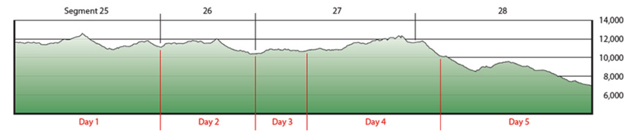
Day One… of this section is seventeen miles of hiking at an average elevation of 11,000 feet. Hiking through the San Juan Mountains on this first day will be a day you will always remember and will want to return. It is very comparable to hiking in the Canadian Rockies, but at a much higher altitude. The path upon which this trail travels is very scenic and every turn creates a new view. The first day is very rewarding, but is also the most difficult. You will see some of the most spectacular views of your life including two Fourteener’s, Mount Wilson and El Diente, where Navajo Sam once resided.
Day Two… is a day hike allowing the hiker to recover from the first days hike. This is a beautiful hike over Black Hawk Pass.
Day Three… is a 6.3 mile hike. Bring a book to read in camp that afternoon!! You will have lots of time to rest up for the next days hike on the hi-line trail.
Day Four… we have a long hike on the hi-line trail. Hi-line trail name implies exactly what it reads…. hiking on top of a spiny ridge with 360 degree views.
Gudy Gaskill states “From the Hi-line Trail (also know as Indian Trail Ridge), a crest of cascading wildflowers, the views of the Hermosa Valley and the La Plata Mountains are extraordinary.” On this day, the hike will top out at Kennebec Pass. From this point The Colorado Trail begins it greatest descent and altitude change.
Day Five… As you would imagine, this is the day of descent to the end of the trail. By no means is this an easy day. It is near twenty miles long but descending approximately 4500 feet. The trail generally follows the canyon of Junction Creek, winding in and out of the numerous steep side drainages.
Please make your own lodging reservations far in advance for the night before the hike and the last night because Durango will fill up quickly.
After the entire group has finished hiking and is waiting at the end of The Colorado Trail, we will shuttle everyone to their cars.
You should be to your vehicles by 6 pm on the last day. Due to the length of the last days hike and logistical issues, there will only be one shuttle available for the group once everyone is finished at the end of the trail.
MEETING DIRECTIONS
Please leave a copy of this information with your emergency contact person.
Meeting Time: 2:00pm
Meeting Place: Durango Transit Center, Durango, CO
More Info: The Shuttle to Camp will take approximately 30 min. Please, eat a lunch before you meet us, or bring a lunch with you. Call 970-531-0115 if you need help finding the meeting location or are running late.
Back to your Vehicle / Pick-up: Our trek will conclude at the western terminus of the Colorado
Trail between 4 and 5 on Friday. After a quick shuttle, we will arrive back at the cars and we will
disband. We suggest you make sleeping arrangements for the evening in Durango.
These Shuttle/Meeting Directions may be subject to change. You will be notified of any changes.
EMERGENCY INFORMATION
Dan Weida – Trekking Field Manager
PHONE or TEXT: 970 531 0963
EMAIL: trekking@coloradotrail.org
Emily Weida – Trekking Office Manager
PHONE or TEXT: 970 509 0115
CAMPSITES
Night 1: Chris Park Group (San Juan County) Off Hwy 550
Day 2: Bolam Pass (La Plata-San Juan County) FR 578
Day 3, 4: Orphan Butte (La Plata County) FR 564
Day 5: Flagler Fork -Head of Junction Creek (La Plata County) FR 171 from CR 204
Note: Campsites may be subject to change due to availability and weather.
Welcome To The Colorado Trail Trekking Program
The Colorado Trail Trekking Program treks allow you to hike 10-20 miles a day on The Colorado Trail while carrying only a daypack. Your tent and personal gear are transported to the next campsite where crewmembers set up camp including; a kitchen tent, toilet tent and shower tent. All meals are planned and cooked for you.

